


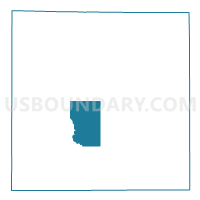
Voting District 0354762000002, Clare County, Michigan
About
Outline

Summary
| Unique Area Identifier | 596270 |
| Name | Voting District 0354762000002 |
| County | Clare County |
| State | Michigan |
| Area (square miles) | 21.74 |
| Land Area (square miles) | 21.49 |
| Water Area (square miles) | 0.25 |
| % of Land Area | 98.87 |
| % of Water Area | 1.13 |
| Latitude of the Internal Point | 43.94790190 |
| Longtitude of the Internal Point | -84.87883840 |
Maps

Graphs
Select a template below for downloading or customizing gragh for Voting District 0354762000002, Clare County, Michigan


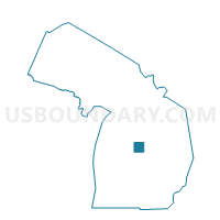
Neighbors
Neighoring Voting District (by Name) Neighboring Voting District on the Map
- Voting District 0353422000001B, Clare County, MI
- Voting District 0353512000001, Clare County, MI
- Voting District 0353716000001, Clare County, MI
- Voting District 0353734000002, Clare County, MI
- Voting District 0354762000001, Clare County, MI
- Voting District 0357758000001, Clare County, MI
- Voting District 0357758000002, Clare County, MI
Top 10 Neighboring County Subdivision (by Population) Neighboring County Subdivision on the Map
- Hayes township, Clare County, MI (4,675)
- Surrey township, Clare County, MI (3,606)
- Grant township, Clare County, MI (3,259)
- Lincoln township, Clare County, MI (1,824)
- Greenwood township, Clare County, MI (1,041)
- Hatton township, Clare County, MI (933)